Adjusting the Line: Special and Relevant Circumstances in Maritime Boundary Delimitation
Explore how international courts apply special and relevant circumstances to modify provisional maritime lines and achieve equitable delimitation under the law of the sea.
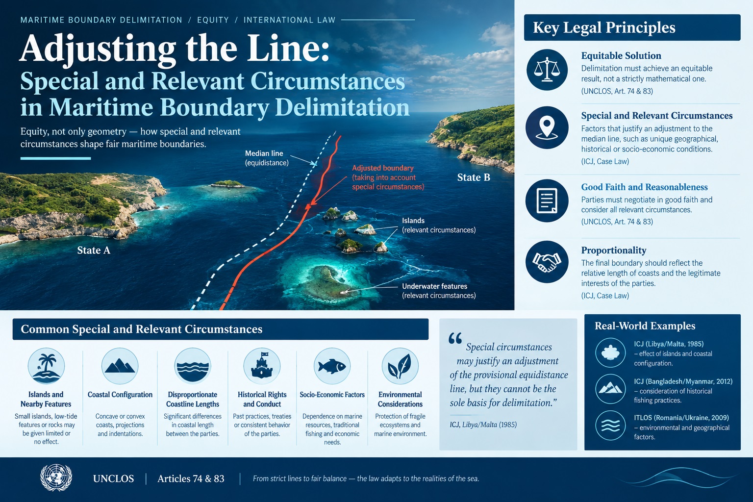
The delimitation of overlapping maritime zones between neighboring coastal states is one of the most intricate exercises in public international law. While modern maritime delimitation relies heavily on geometric techniques, such as the construction of an equidistant or median line, geometry alone rarely delivers justice. Strict adherence to mathematical equidistance can magnify geographical anomalies, creating disproportionately harsh outcomes for one state while providing an unearned windfall to another. To prevent such distortions, international law integrates corrective factors known across treaty provisions and jurisprudence as special circumstances and relevant circumstances.
These legal mechanisms serve as the primary vehicle through which courts and tribunals balance the pursuit of legal certainty with the imperative of achieving an equitable solution. Whether addressing coastal concavity that cuts off a state from its maritime projection, assessing the disproportionate effect of tiny offshore features, or evaluating deep seabed troughs, international adjudicators utilize these circumstances to modify provisional boundaries. Understanding their role reveals how international jurisprudence navigates between rigid legal geography and individualized equity.
The Legal Foundations: From Geneva to Montego Bay
The vocabulary of maritime delimitation developed across two distinct eras of codification in twentieth-century international law. The concept of special circumstances first gained formal treaty recognition in the 1958 Geneva Conventions. Under Article 12 of the Convention on the Territorial Sea and the Contiguous Zone, as well as Article 6 of the Convention on the Continental Shelf, delimitation between opposite or adjacent states was to be determined by agreement, and in the absence of agreement, by an equidistant median line, unless another boundary line is justified by reason of historic title or other special circumstances.
By the time the Third United Nations Conference on the Law of the Sea concluded with the adoption of the United Nations Convention on the Law of the Sea (UNCLOS) in 1982, the legal framework had shifted significantly. While Article 15 of UNCLOS retained the median line and special circumstances formulation for the territorial sea, Articles 74 and 83 addressed the Exclusive Economic Zone (EEZ) and the continental shelf within 200 nautical miles (NM) with intentionally broad language. These articles stipulate that delimitation shall be effected by agreement on the basis of international law, as referred to in Article 38 of the Statute of the International Court of Justice, in order to achieve an equitable solution.
The deliberate omission of explicit references to either equidistance or special circumstances in Articles 74 and 83 reflected a protracted diplomatic stalemate between two competing factions during the negotiations: the median line group, which championed geometric certainty, and the equitable principles group, which favored discretion based on individual coastal circumstances. Rather than choosing between them, the drafters elevated the equitable result to the governing standard, creating space for international tribunals to develop the doctrine of relevant circumstances through customary international law.
Functional Convergence of Special and Relevant Circumstances
Despite the linguistic distinction between the special circumstances of the 1958 Conventions and UNCLOS Article 15 on the one hand, and the relevant circumstances invoked in EEZ and continental shelf disputes on the other, international jurisprudence has effectively unified the two concepts.
The International Court of Justice (ICJ) formalized this harmonization in several benchmark rulings. In the 1993 Jan Mayen case between Denmark and Norway, the Court explicitly addressed the relationship between the two terms, determining that the special circumstances rule under Article 6 of the 1958 Geneva Convention and the relevant circumstances approach applied to achieve an equitable result under customary law are functionally equivalent. Both serve to verify whether a provisional equidistance line produces an inequitable or distorting effect that requires an adjustment.
This harmonization constitutes the structural core of the standard three-stage maritime delimitation methodology crystallized by the ICJ in the 2009 Black Sea case between Romania and Ukraine. Under this structured process:
- The court establishes a provisional equidistance or median line using objectively determined base points along the relevant coasts.
- The court examines whether there are special or relevant circumstances calling for an adjustment or shifting of the provisional line to achieve an equitable result.
- The court conducts a disproportionality test to confirm that the resulting boundary does not lead to a marked imbalance between the ratio of coastal lengths and the ratio of water and seabed areas allocated to each party.
Within this framework, relevant circumstances operate exclusively at the second stage. They do not prevent the drawing of a provisional line; rather, they serve as legal and factual justification for adjusting that line.
Geographical Factors: The Primary Relevant Circumstances
The fundamental principle governing maritime rights is that the land dominates the sea. It follows that geographical factors constitute the overwhelming majority of recognized relevant circumstances in international jurisprudence. Because coastal configuration directly generates maritime entitlements, abnormalities in that configuration are the first factors scrutinized by courts.
Coastal Concavity and the Cut-Off Effect
Among the most influential geographical factors is coastal concavity. When a coastline exhibits a concave curve, adjacent states situated on either side of a central state can inadvertently squeeze the central state out of its rightful ocean space if strict equidistance lines are drawn. As the lines extend seaward, they converge in front of the concave coast, producing a severe cut-off effect that prevents the middle state from projecting into open waters.
The classic illustration of this phenomenon arose in the 1969 North Sea Continental Shelf cases. The Federal Republic of Germany possessed a concave coastline sandwiched between the convex coasts of Denmark and the Netherlands. The ICJ recognized that drawing strict equidistance lines from these adjacent coasts produced an inequitable result by cutting Germany off from the central portion of the North Sea shelf. While the Court did not draw the boundary itself, it affirmed that a coastal configuration that produces a disproportionate cut-off constitutes a circumstance requiring equitable modification.
Subsequent courts have repeatedly treated concavity as a compelling relevant circumstance. In the 2012 ITLOS Bay of Bengal dispute between Bangladesh and Myanmar, and the subsequent 2014 Annex VII Arbitral Award between Bangladesh and India, international tribunals modified provisional equidistance lines specifically to alleviate the severe cut-off effect imposed on Bangladesh by the sharp concavity of the Bay of Bengal coastline.
Disparity in Coastal Lengths
Another geographical factor frequently evaluated under the second stage is a substantial disparity in the lengths of the parties relevant coasts. International law does not mandate mathematical proportionality; it does not allocate maritime space in direct ratio to coastal meterage. However, an extreme discrepancy in coastal length cannot be ignored if a strict median line would grant nearly identical marine space to two states with vastly unequal coastlines.
In the Jan Mayen case, the mainland coast of Greenland possessed a relevant coastal length more than nine times longer than the coast of the small Norwegian island of Jan Mayen. The ICJ found this extreme disparity to be a relevant circumstance requiring an eastward shift of the median line toward Jan Mayen to provide Greenland with a larger portion of the continental shelf and fishery zone. However, minor or moderate differences in length are routinely dismissed by courts as normal geographical features that do not warrant line adjustments.
The Presence, Size, and Position of Islands
Islands, islets, and isolated maritime features represent perhaps the most frequent source of dispute in maritime delimitation. Under Article 121 of UNCLOS, an island naturally generates its own territorial sea, contiguous zone, EEZ, and continental shelf, provided it can sustain human habitation or an economic life of its own. However, when situated in close proximity to an opposing mainland coast or positioned well seaward of its sovereign state, an island can exert a disproportionate distorting effect on an equidistance boundary.
Tribunals handle islands through several established methods depending on their size, location, and relationship to the mainland:
- Full Effect: The island is treated identically to a mainland coast and utilized fully as a base point for constructing the provisional equidistance line. This is typical for substantial, populated islands located close to the coast of the sovereign state.
- Partial or Half Effect: The tribunal draws two hypothetical lines, one giving the island full effect and another giving it no effect, and adopts a boundary halfway between them. The 1977 Anglo-French Continental Shelf Arbitration famously applied half effect to the British Channel Islands in the middle of the English Channel and the Scilly Isles off Cornwall.
- Enclaving: If an island lies very close to the coast of another sovereign state, giving it even partial effect could amputate the mainland state from its natural maritime projection. In such cases, tribunals frequently enclave the island, giving it a modest belt of territorial sea (often 12 NM) while running the broader continental shelf and EEZ boundary around it.
- Zero Effect: Uninhabited rocks, isolated islets, or tiny low-tide elevations that distort maritime space out of all proportion to their geographic scale are often stripped of any delimitation effect. In the 2009 Black Sea case, the ICJ refused to allow Serpents Island to affect the EEZ and continental shelf delimitation between Romania and Ukraine, treating it as an isolated feature that should not alter the general coastal projection.
Geology and Geomorphology: Diminishing Relevance Within 200 Nautical Miles
Historically, under the 1958 Geneva Convention and the early customary law articulated in the 1969 North Sea cases, the continental shelf was defined primarily by the concept of natural prolongation—the physical extension of the landmass beneath the sea. Consequently, states frequently argued that geological faults, deep submarine trenches, or distinct seabed sediment layers constituted special circumstances that should dictate boundary lines.
The adoption of UNCLOS fundamentally curtailed the relevance of geomorphology within the exclusive economic zone. Article 56 and Article 76 introduce the distance criterion, establishing that every coastal state possesses sovereign rights over the seabed and water column out to 200 NM from its baselines, regardless of the physical nature of the ocean floor.
The ICJ confirmed this paradigm shift in the 1985 Continental Shelf case between Libya and Malta. The Court ruled that because both states asserted claims within 200 NM of their coasts, the geological characteristics of the seabed—specifically a significant rift system known as the Pelagian Block—were completely irrelevant to the delimitation. Within 200 NM, legal distance supersedes physical geology.
However, geomorphology retains critical importance in one specific context: delimitation of the continental shelf beyond 200 NM (the extended continental shelf). In the 2012 Bangladesh/Myanmar judgment and subsequent cases, international bodies recognized that where overlapping claims extend to the outer edge of the continental margin, natural prolongation and the location of the continental margin remain relevant factual and legal considerations in determining the boundary line.
Non-Geographical Factors: High Bar, Limited Success
Parties to maritime disputes frequently invoke non-geographical arguments, including economic dependency, historical fishing patterns, navigation routes, national security, and state conduct. International jurisprudence reveals a consistent and strict reluctance to modify provisional lines on the basis of these subjective criteria.
Economic Considerations and Living Resources
States routinely plead that access to specific fishing grounds, offshore hydrocarbon fields, or broader economic survival warrants an adjustment of the maritime boundary. With rare exceptions, courts have rejected these claims.
In the 1982 Continental Shelf case between Tunisia and Libya, and the 1984 Gulf of Maine case between Canada and the United States, the ICJ held that economic considerations are generally variable, unpredictable, and subject to rapid change over time. A maritime boundary is permanent; tethering a permanent legal border to shifting economic circumstances or fluctuating fish migration patterns would undermine regional stability.
The primary exception occurs where a proposed boundary would cause catastrophic economic consequences for a coastal population entirely dependent on a local fishery for survival. Short of imminent economic destruction, resource access is rarely deemed a relevant circumstance sufficient to move an equidistant line, although it may inspire cooperative management zones across finalized borders.
Security and Defense Interests
Security interests have occasionally surfaced as a factor, particularly regarding adjacent coastal boundaries that terminate near a major naval installation or commercial harbor. In the 1909 Grisbådarna case between Norway and Sweden, long before modern codification, maritime security was noted. In modern practice, courts rarely cite defense as an autonomous relevant circumstance, but they deliberately avoid constructing boundaries that run excessively close to a state's coastline or naval choke points to prevent navigational friction and sovereign conflict.
Conduct of the Parties and Historic Titles
Historic title is explicitly enumerated alongside special circumstances in UNCLOS Article 15. Where a state can prove ancient, continuous, and uncontested exercise of sovereignty over a maritime area with the acquiescence of neighboring states, historic title can displace the median line.
Beyond formal historic title, states often present past conduct, such as unilateral oil concession lines, seismic survey permits, or naval patrol limits, as evidence of a tacit agreement or a relevant circumstance. In the 2007 territorial and maritime dispute between Nicaragua and Honduras in the Caribbean Sea, the ICJ acknowledged that mutual acquiescence to an established oil concession line could influence boundary decisions. However, the threshold for demonstrating a legally binding tacit boundary is exceptionally high; mere administrative unilateralism by one party does not qualify as a relevant circumstance.
Comparative Table: Categories of Circumstances
| Category | Specific Circumstance | Judicial Weight | Key Jurisprudential Precedent |
|---|---|---|---|
| Geographical | Coastal Concavity (Cut-Off Effect) | Very High | North Sea Continental Shelf (1969); Bangladesh/Myanmar (2012) |
| Geographical | Island Distortions and Enclaving | Very High | Anglo-French Arbitration (1977); Black Sea (2009) |
| Geographical | Coastal Length Disparities | Moderate to High | Jan Mayen (1993); Nicaragua v. Colombia (2012) |
| Geomorphological | Submarine Trenches / Rifts | Negligible within 200 NM | Libya/Malta (1985) |
| Socio-Economic | Fishing Dependence / Livelihood | Very Low (Except Catastrophic) | Gulf of Maine (1984); Jan Mayen (1993) |
| Historical | Historic Rights and Titles | High (When Strictly Proven) | Grisbådarna (1909); UNCLOS Article 15 |
The Delicate Balance: Discretion vs. Predictability
The role of special and relevant circumstances in maritime delimitation demonstrates the perpetual tension within international law between legal certainty and corrective equity. If the law relied solely on unbending geometric equidistance, it would enforce geographic anomalies and entrench manifest injustice. Conversely, if delimitation were left entirely to untethered judicial discretion to reach an equitable result without standard rules, states would face unpredictable arbitrariness.
By subordinating relevant circumstances to the second stage of a clear, three-stage process, international jurisprudence has achieved an effective balance. Equidistance provides the objective baseline; relevant circumstances provide the corrective lens. Through decades of international rulings, courts have carefully circumscribed this corrective power, establishing that not every geographic imperfection qualifies as an anomaly, and that non-geographic grievances rarely displace coastal geometry.
Ultimately, special and relevant circumstances do not exist to refashion nature or undo geography. Their fundamental purpose is to ensure that geography speaks with equal voice for all coastal states, producing maritime boundaries that are stable, recognized, and genuinely equitable.
Comments
No comments yet.