Evidence in Maritime Disputes: Jurisprudential Standards, Digital Forensics, and Ocean Boundaries
An exhaustive analysis of evidentiary burdens, digital sensor proof, and judicial fact-finding across the ICJ, ITLOS, and international maritime arbitration.
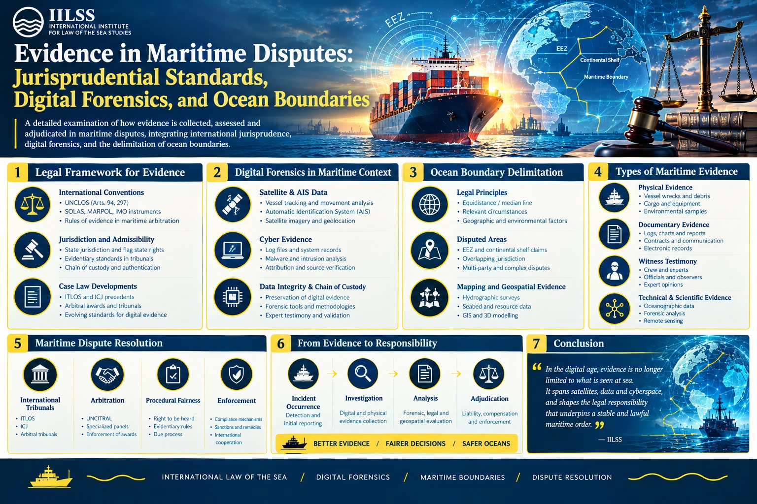
The adjudication of international maritime disputes operates within a distinct epistemological domain. Unlike terrestrial conflicts, where physical monuments, entrenched settlements, and static topographies offer tangible records, ocean space presents an evidentiary environment characterized by fluid dynamics, fleeting physical traces, and sovereign opacity. Whether sitting in the Peace Palace at The Hague, the premises of the International Tribunal for the Law of the Sea (ITLOS) in Hamburg, or arbitral chambers convened under Annex VII of the United Nations Convention on the Law of the Sea (UNCLOS), adjudicators must evaluate legal claims where critical facts vanish into the oceanic water column or lie buried under contested cartographic layers. Over the past seven decades, the law of maritime evidence has evolved from its origin in classical diplomatic records and ship logs into a complex discipline synthesizing satellite geodesy, acoustic hydrography, electronic vessel sensors, and indirect judicial inference.
This evidentiary architecture operates under the tension between procedural flexibility and legal certainty. International tribunals, free from the prescriptive codes of evidence common to municipal common-law jurisdictions, adhere to the principle of free evaluation of evidence. Yet, this discretion does not imply an absence of doctrine. The jurisprudential output of the International Court of Justice (ICJ), ITLOS, and ad hoc tribunals under the Permanent Court of Arbitration (PCA) reveals strict tests governing burdens of proof, stringent rules on the probative value of technological records, and sophisticated doctrines regarding circumstantial inferences when coastal states conceal maritime evidence. As contemporary maritime disputes increasingly center on critical undersea infrastructure sabotage, clandestine resource extraction, dark-fleet vessel operations, and complex scientific projections of sea-level rise, the evidentiary framework of the oceans undergoes unprecedented strain.
What is the burden of proof in international maritime disputes?
The foundational procedural maxim governing evidence in international adjudication is actori incumbit probatio: the claimant must establish the facts underpinning its legal submission. In maritime litigation, this canon is consistently applied yet fundamentally nuanced. Article 48 of the ICJ Statute and Articles 77 and 78 of the ITLOS Rules give both fora broad competence to determine the conduct of the case and the admissibility of evidentiary submissions, leaving the formal allocation of the burden of proof to substantive jurisprudence.
In maritime delimitation claims, the strict binary of claimant versus respondent frequently dissolves. Delimitation is fundamentally an objective juridical process directed toward reaching an equitable result pursuant to Articles 74(1) and 83(1) of UNCLOS. As the ICJ articulated in the Maritime Delimitation in the Black Sea (Romania v. Ukraine) judgment, the court is tasked with establishing an equitable delimitation line based on law and objective geography, not merely endorsing the line presented by either party. Consequently, while a party claiming the existence of a historic title, special circumstance, or unusual coastal feature bears the legal burden of producing evidence to substantiate that circumstance, the overall boundary delimitation process does not operate as an ordinary civil claim where failure of proof by one party defaults to the absolute victory of the other.
Conversely, in disputes involving alleged unlawful interdictions, environmental pollution, or the breach of sovereign rights within an Exclusive Economic Zone (EEZ), the burden of proof remains adversarial. In the M/V Saiga (No. 2) Case (Saint Vincent and the Grenadines v. Guinea), ITLOS held that Guinea bore the burden of proving that its customs authorities had justifiable legal grounds under Article 111 of UNCLOS to exercise the right of hot pursuit against the vessel. Because Guinea failed to produce precise log entries, synchronized radar trackings, or clear radio logs establishing that the pursuit commenced within its territorial waters or contiguous zone without interruption, ITLOS rejected the legality of the interdiction.
A persistent doctrinal debate concerns the standard of proof applied by ocean tribunals. International procedural law notoriously avoids domestic formulations such as proof beyond a reasonable doubt or preponderance of the evidence. Instead, tribunals calibrate their standard to the gravity of the international wrong alleged. Where a sovereign state is accused of grave violations of international law—such as armed confrontation at sea, aggressive sovereign coercion, or state-sponsored environmental devastation—the ICJ and ITLOS demand evidence that is fully conclusive and leaves no room for reasonable alternative hypotheses, as observed in the Application of the Convention on the Prevention and Punishment of the Crime of Genocide and reflected in maritime security findings within the Guyana v. Suriname Annex VII arbitration.
In interim proceedings, such as requests for the prescription of provisional measures under Article 290 of UNCLOS, or prompt release applications under Article 292, the standard of proof shifts considerably. In prompt release actions, as demonstrated across early jurisprudence including the Camouco and Monte Confurco cases, the applicant need only establish a plausible or prima facie showing that the detention is inconsistent with international law and that the bond demanded by the detaining coastal state is unreasonable. The tribunal does not determine the definitive merits of the underlying municipal charges, thereby lowering the evidentiary threshold to preserve the commercial utility of the vessel and the liberty of its crew pending domestic proceedings.
The Circumstantial Matrix: Inference and Sovereign Control from Corfu Channel to Modern Jurisprudence
Direct documentary or physical proof of sovereign maritime infractions is rarely accessible. States executing covert naval deployments or clandestine marine operations do not routinely disclose operational diaries or telecommunication intercepts. To prevent a manifest failure of justice (non liquet), international maritime jurisprudence has developed rules concerning indirect, circumstantial, and inferential evidence.
The locus classicus remains the landmark judgment of the ICJ in the Corfu Channel Case (United Kingdom v. Albania) (1949). The dispute arose from the detonation of British naval vessels by moored naval mines within Albanian territorial waters. Confronting the reality that the United Kingdom could not produce direct evidence proving that Albania itself had laid the mines, the Court addressed whether Albania’s exclusive territorial jurisdiction over its littoral waters allowed an adverse evidentiary inference:
A State on whose territory or in whose waters an act contrary to international law has occurred cannot be allowed to evade responsibility by shifting the burden of proof onto the victim state, nor can it rely on the impossibility of direct proof where circumstantial evidence demonstrates exclusive territorial control and operational awareness.
The Court held that exclusive territorial control altered the evidentiary mechanics. While territorial sovereignty does not reverse the burden of proof automatically, it permits the applicant to resort to a series of indirect facts and circumstantial inferences that, when linked together, establish coastal state knowledge. The ICJ demanded that such circumstantial evidence be clear, concordant, and leave no room for alternative explanations. Because Albania possessed operational observation posts monitoring the strait and the laying of a minefield required substantial surface vessel maneuvers over several days, the Court inferred that Albania possessed constructive or actual knowledge of the field’s presence, triggering an international obligation to warn approaching vessels.
In the modern era of hybrid oceanic warfare, grey-zone naval maneuvers, and damage to subsea telecommunication cables and pipeline infrastructure, the Corfu Channel doctrine possesses immense vitality. When automated underwater vehicles (AUVs) or subsea sabotage operations sever data cables within a state’s territorial sea or contiguous zone, claimant states increasingly invoke territorial control and surveillance presence to argue constructive knowledge. However, modern jurisprudence resists expanding this inference beyond close inshore waters. In the broad expanse of the EEZ or the High Seas, where states exercise only functional sovereign rights or high-seas freedoms, the factual predicate of exclusive spatial control collapses, requiring claimants to provide affirmative corroboration rather than resting on territorial presumptions.
Furthermore, international maritime tribunals have consistently drawn adverse inferences against states that systematically withhold evidence within their control. In the ARA Libertad Case (Argentina v. Ghana) before ITLOS, and similarly throughout commercial maritime arbitrations under the rules of the London Maritime Arbitrators Association (LMAA), if a party willfully suppresses engine room data logs, radar imagery, or marine casualty investigations without invoking a valid privilege, the adjudicatory body holds the authority to infer that the withheld material would have confirmed the opposing party's factual assertions.
How is evidence evaluated in maritime delimitation disputes?
Maritime boundary delimitation jurisprudence constitutes the most technically rigorous evidentiary theater in international law. Across hundreds of miles of continental shelf and water column, adjudicators must reconcile historic colonial cartography, geodetic datums, coastal geomorphology, and complex tidal fluctuations. In resolving these conflicts, the ICJ and ITLOS have developed a strict hierarchy of proof.
Historically, parties frequently submitted historical maps, nautical charts, and ancestral travelogues to demonstrate historic consolidation of title over maritime spaces. However, the evidentiary value of cartographic material has undergone decisive demotion. As clarified in the PCA Eritrea/Yemen arbitration and reaffirmed in the ICJ Territorial and Maritime Dispute (Nicaragua v. Colombia) judgment, maps are rarely autonomous legal instruments. Unless a map is annexed directly to a valid boundary treaty and expressly intended by the parties to delineate the legal boundary, cartography serves merely as secondary or corroborative evidence of physical geography or official administrative attitudes.
Modern delimitation tribunals prioritize objective, empirical hydrography over cartographic impressions. The identification of base points along the low-water line—the foundational step for constructing the provisional equidistance line mandated by the three-stage delimitation methodology—requires accurate geodetic data. Disagreements over whether a coastal feature qualifies as an island, an islet, a low-tide elevation, or a submerged reef often turn on fractional vertical measurements. In the Dispute concerning delimitation of the maritime boundary between Mauritius and Maldives in the Indian Ocean (Mauritius/Maldives) before the Special Chamber of ITLOS, and the Bay of Bengal Maritime Boundary Arbitration (Bangladesh v. India), the precise calculation of tidal baselines compelled tribunals to evaluate bathymetric surveys, satellite-derived bathymetry, and complex tidal models to verify whether points were above water at mean high-water spring tides.
The definitive test regarding the evidentiary classification of maritime features emerged in the South China Sea Arbitration (The Republic of Philippines v. The People's Republic of China) under UNCLOS Annex VII (PCA Case No. 2013-19). Confronted with China's expansive maritime claims based on historic rights and the construction of artificial installations atop remote maritime features in the Spratly archipelago, the Tribunal was required to determine the legal status of features under Article 121 of UNCLOS.
The Tribunal established a foundational evidentiary principle: the insular status of a feature under Article 121 must be assessed based on its natural, pristine condition prior to human intervention, dredging, and land reclamation. Because China declined to participate directly in the proceedings, the Tribunal exercised its independent investigative powers under Article 9 of Annex VII. It commissioned independent hydrographic and geographical experts to scrutinize archival naval surveys, historic British Admiralty sailing directions from the 19th and early 20th centuries, aerial surveys, and satellite time-series data. The Tribunal determined that historical evidence describing conditions before modern engineering is far superior to contemporary physical manifestations altered by artificial means, concluding that none of the Spratly features were naturally capable of sustaining human habitation or an economic life of their own under Article 121(3).
| Adjudicatory Forum | Primary Governing Rules | Default Burden of Proof | Typical Standard of Proof | Approach to Expert Evidence |
|---|---|---|---|---|
| International Court of Justice (ICJ) | ICJ Statute (Arts. 48–53); Rules of Court | Actori incumbit probatio; functional flexibility in objective delimitation | Sliding scale; conclusive evidence required for grave sovereign misconduct | Parties appoint experts; Court possesses rarely exercised power to appoint under Art. 50 |
| International Tribunal for the Law of the Sea (ITLOS) | ITLOS Statute; ITLOS Rules (Arts. 77–88) | Onus on asserting party; reversed or shared on functional treaty regimes | Prima facie for prompt release; high threshold for substantive violations | Direct examination of party experts; Court may summon independent witnesses or experts |
| PCA / UNCLOS Annex VII Tribunals | UNCLOS Annex VII (Art. 5); Tribunal-specific procedural orders | Asserting party; active independent fact-finding where a party defaults (Art. 9) | Preponderance of reliable evidence; objective scrutiny of physical data | Extensive reliance on tribunal-appointed independent technical experts and hydrographers |
| Commercial Maritime Arbitration (LMAA / SMA) | National Arbitration Acts; LMAA/SMA Procedural Terms | Claimant on initial claim; respondent on set-offs and counterclaims | Balance of probabilities / Preponderance of the evidence | Adversarial party-appointed technical and master mariner expert witnesses |
Digital Epistemology: ECDIS, VDR, AIS, and Remote Sensing in the Courtroom
The contemporary maritime domain has generated a digital evidentiary ecosystem. Traditional paper logbooks, frequently vulnerable to post-incident alteration, have been superseded by sophisticated electronic recording mechanisms mandated by the International Maritime Organization (IMO) under the International Convention for the Safety of Life at Sea (SOLAS). When ships collide, run aground, or damage subsea cables, adjudicators rely on the recovery and forensic validation of this digital trail.
Central to modern maritime casualty litigation are Voyage Data Recorders (VDRs) and Electronic Chart Display and Information Systems (ECDIS). Mandated under SOLAS Chapter V, Regulation 20, VDRs continuously capture bridge audio, VHF communications, radar sweeps, engine orders, rudder angles, hull stress indicators, and gyrocompass readings. In collision proceedings before domestic admiralty courts and international commercial tribunals, raw VDR data represents the preeminent objective proof of navigational behavior, decisively determining compliance with the International Regulations for Preventing Collisions at Sea (COLREGs).
However, the transition from analog to digital evidence introduces complex challenges concerning authenticity, chain of custody, and forensic integrity. Unlike paper documents, digital recordings can be corrupted, degraded, or deliberately manipulated. Tribunals require proof that the data was extracted via certified maritime cyber-forensic protocols. In instances where bridge audio files are obscured by ambient sea noise or engine vibrations, acoustic spectrum analysis is deployed to reconstruct verbal commands between the master and watchstanders. If an electronic log has been overwritten or shows temporal gaps, tribunals routinely apply negative evidentiary presumptions, treating the disruption as evidence of gross navigational negligence.
Automatic Identification System (AIS) data presents a distinct evidentiary paradox. While AIS broadcasts provide comprehensive geospatial tracking for worldwide commercial navigation, the signal is prone to spoofing, intentional signal cessation (going dark), and atmospheric degradation. In disputes concerning illegal, unreported, and unregulated (IUU) fishing, or sanctions circumvention through ship-to-ship transfers, parties frequently present AIS tracks to demonstrate vessel positions.
Adjudicators have become cautious regarding uncorroborated AIS data. In the Enrica Lexie Incident (Italy v. India) Annex VII arbitration, Italy and India submitted conflicting positions regarding the navigational track and exact geographical location of the Italian oil tanker and the Indian fishing vessel St. Antony when Indian security personnel opened fire. The arbitral tribunal had to compare fragmented AIS logs with satellite transponder data, radar range-bearing calculations recorded by onshore coast guard facilities, and contemporaneous GPS fixes. The jurisprudence indicates that while AIS data creates a strong factual presumption of position, it does not constitute unassailable proof. It must be corroborated by independent telemetry if one party establishes technical interference, physical antenna shielding, or electronic tampering.
Earth observation technology has emerged as an indispensable instrument of oceanic proof. Synthetic Aperture Radar (SAR) imagery, optical satellite photography, and spaceborne radiometry have fundamentally reshaped environmental enforcement. In marine pollution claims under the International Convention for the Prevention of Pollution from Ships (MARPOL) and the International Convention on Civil Liability for Oil Pollution Damage (CLC), satellite SAR data can detect oceanic surface slicks caused by illicit hydrocarbon discharge. Because hydrocarbon films dampen ocean capillary waves, SAR sensors record distinct dark patches against the reflective ocean surface.
To satisfy judicial evidentiary thresholds, remote sensing evidence must meet a demanding series of criteria. Adjudicators evaluate the sensor resolution, atmospheric interference parameters, oceanographic current models, and the exact temporal delta between the vessel's passage and the satellite acquisition. In the landmark dispute over marine pollution before the European Court of Justice, the validation of satellite imagery in Intertanko and Others highlighted that remote sensing serves as prima facie evidence of an illegal discharge, but must be corroborated by drift models or physical water sampling to confirm the chemical signature of the pollutant and definitively anchor liability to a specific shipowner.
The Role of Independent Experts and Scientific Proof in Marine Environmental Litigation
As maritime disputes increasingly incorporate complex environmental, ecological, and geomorphological issues, international tribunals struggle to manage scientific proof. This tension crystallizes around how tribunals evaluate scientific experts: should tribunals rely solely on party-appointed experts, or exercise their inherent powers to retain court-appointed technical assessors?
The traditional approach, epitomized by common-law procedural habits, relied on parties presenting their own expert witnesses. This methodology faced significant criticism from the ICJ itself in the Case Concerning Pulp Mills on the River Uruguay (Argentina v. Uruguay) (2010). Although not strictly a maritime dispute, the procedural ruling established a vital benchmark for all environmental and marine litigation. In Pulp Mills, the Court criticized the practice of parties introducing scientific experts as counsel or legal advocates within their delegations, clarifying that experts who present empirical evidence must be introduced as formal witnesses subject to cross-examination and judicial interrogation.
Furthermore, several judges issued pointed dissents and separate opinions in Pulp Mills, arguing that international judges lack the scientific training necessary to evaluate complex modeling, ecotoxicological thresholds, and oceanographic dispersion data. They maintained that the Court should freely deploy Article 50 of the ICJ Statute, which allows it to entrust an individual, bureau, commission, or other body with inquiry or expert assessment. The reliance on party-appointed experts, colloquially termed battle of the experts, risks paralytic adjudication where contradictory scientific models cancel each other out, prompting the tribunal to resort to narrow procedural defaults rather than resolving empirical realities.
The ICJ embraced this lesson in the Maritime Delimitation in the Caribbean Sea and the Pacific Ocean (Costa Rica v. Nicaragua) and the joined case regarding Land Boundary in the Northern Part of Isla Portillos. Confronting acute disputes regarding the dynamic geomorphology of a fragile wetland canal (caño) and coastal sandspits, the Court took the unusual step of appointing its own independent experts under Article 67 of the Rules of Court to conduct on-site geodetic and hydrological inspections. The findings of these court-appointed experts were treated as objective baseline facts, neutralizing the hyper-partisan scientific models submitted by the disputing states.
In the maritime domain, this approach reached maturity in the ITLOS advisory proceedings on ocean environmental protection. In its 2024 Advisory Opinion on Climate Change and International Law (Request for an Advisory Opinion submitted by the Commission of Small Island States on Climate Change and International Law), ITLOS relied comprehensively on the objective, peer-reviewed scientific assessments of the Intergovernmental Panel on Climate Change (IPCC). ITLOS accepted the IPCC findings as authoritative scientific consensus, using them as established evidentiary foundation to interpret the substantive obligations of state parties under Part XII of UNCLOS to prevent, reduce, and control marine pollution from greenhouse gas emissions.
Similarly, in the Whaling in the Antarctic (Australia v. Japan: New Zealand intervening) judgment, the ICJ established a crucial standard for reviewing scientific evidence. The Court declined to act as a scientific committee deciding what constitutes good science; instead, it applied an objective evidentiary test. It examined whether the research design, vessel kill quotas, and data collection methodologies were reasonable in relation to the stated scientific objectives. By testing the internal coherence of Japan’s scientific whaling program against demonstrable operational metrics, the Court concluded that the empirical data contradicted the program's stated purpose, establishing an important precedent for maritime conservation litigation.
Evidentiary Privileges, National Security, and Maritime Espionage
A persistent obstacle in maritime adjudication is the clash between sovereign security and procedural disclosure. Navies operate in secrecy. When maritime incidents involve naval warships, coast guard vessels, or auxiliaries, the rules of evidence collide with international immunities and national security privileges.
Under Articles 32, 95, and 96 of UNCLOS, warships and government ships operated for non-commercial purposes enjoy complete sovereign immunity on the high seas and within foreign exclusive economic zones from the jurisdiction of foreign states. While this substantive immunity does not exempt the flag state from international responsibility for unlawful acts, it creates severe evidentiary barriers. An international tribunal cannot compel a state to deliver its naval tactical logs, secure satellite communication transcripts, or sensitive hydrophone arrays without that state's sovereign consent.
This conflict was highlighted in the Dispute Concerning the Detention of Ukrainian Naval Vessels and Servicemen (Ukraine v. Russian Federation) before an Annex VII arbitral tribunal (PCA Case No. 2019-28). The dispute arose from the Kerch Strait incident of November 2018, where Russian coast guard and naval units intercepted and fired upon three Ukrainian naval vessels. Russia raised preliminary objections, arguing the tribunal lacked jurisdiction because Article 298(1)(b) of UNCLOS permits states to exclude military activities from compulsory dispute settlement.
The evidentiary challenge required determining whether the underlying acts constituted military activities or law-enforcement operations. The tribunal held that this classification cannot be established solely by the subjective assertions of the states involved. Instead, the determination must rely on an objective evidentiary analysis of the vessels' actions, navigational maneuvers, communication records, and rules of engagement. When Russia refused to release internal operational defense directives, the tribunal evaluated intercepted ship-to-shore communications released by Ukrainian intelligence, maritime traffic recordings, and contemporaneous public statements by sovereign officials.
The admissibility of covertly or unlawfully obtained evidence represents another unsettled dimension of modern maritime law. In international adjudication, there is no blanket exclusionary rule comparable to the American domestic doctrine of the fruit of the poisonous tree. In the Corfu Channel case, British naval minesweepers conducted Operation Retail in Albanian waters to gather the very mine specimens later submitted as evidence to the Court. Although the ICJ explicitly held that the British minesweeping operation violated Albania’s territorial sovereignty, it notably admitted the collected physical mines into evidence, treating the breach of sovereign inviolability as a separate legal wrong that did not automatically compromise the material's factual veracity.
Contemporary practice preserves this pragmatic evidentiary tradition. Arbitral and judicial tribunals consistently accept intercepted communications, open-source maritime intelligence, and third-party satellite surveillance, provided the evidence can be reliably authenticated and is pertinent to resolving the legal dispute. As long as the opposing party is granted a full and fair opportunity to examine, challenge, and rebut the submitted material in accordance with the procedural guarantee of equality of arms (audi alteram partem), international maritime fora prioritize factual transparency over domestic evidentiary technicalities.
The Forensic Horizon: Marine Autonomous Systems and Deep-Sea Mining
As the international community confronts the exploitation of deep seabed mineral resources in the Area under Part XI of UNCLOS, the law of evidence must adapt to a new frontier. Prospective disputes concerning polymetallic nodule harvesting, environmental plumes, and benthic ecological devastation will take place thousands of meters beneath the sea surface, where no human eye can directly observe the alleged infractions.
Litigation before the Seabed Disputes Chamber of ITLOS will rely completely on robotic sensory instrumentation: autonomous underwater vehicles (AUVs), fiber-optic monitoring landers, acoustic backscatter sonars, and environmental DNA (eDNA) sampling. Determining whether a contractor has caused serious harm to the marine environment under Article 145 of UNCLOS will depend on baseline biological measurements that are inherently volatile and incomplete.
In this high-uncertainty theater, the traditional burden of proof faces substantial doctrinal revision via the Precautionary Principle. As the Seabed Disputes Chamber noted in its historic 2011 Advisory Opinion on Responsibilities and Obligations of States with Respect to Activities in the Area, where scientific knowledge concerning deep-sea ecological consequences is insufficient, states and contractors cannot rely on the lack of full scientific certainty to postpone cost-effective conservation measures. Juridically, the precautionary approach subtly shifts the evidentiary burden: once an applicant demonstrates a credible risk of catastrophic or irreversible marine environmental degradation, the defending entity must present affirmative scientific data demonstrating that its mining technologies and plume containment systems will avert such harm.
Similarly, the proliferation of Maritime Autonomous Surface Ships (MASS) will destabilize long-standing evidentiary concepts of navigational fault. When an uncrewed commercial cargo vessel collides with a conventional fishing trawler, liability cannot be resolved by scrutinizing human bridge reactions or interrogating master mariners. Adjudicators will be compelled to inspect millions of lines of neural network code, algorithm training sets, algorithmic sensor integration pipelines, and remote-control command links. The evidentiary core will shift from the human witness to the software architecture. Tribunals will confront questions of electronic product liability and code auditing, evaluating whether an artificial intelligence model maintained a proper look-out as required by Rule 5 of the COLREGs.
Conclusion
The law of evidence in maritime disputes is undergoing a fundamental transformation. What was once an informal procedural system anchored in the sovereign word of coastal states and the hand-written logs of master mariners has evolved into a multifaceted technological and scientific discipline. Across the International Court of Justice, the International Tribunal for the Law of the Sea, and ad hoc arbitral panels, adjudicators have structured a jurisprudence capable of operating from deep ocean trenches to the reaches of satellite surveillance.
This evidentiary jurisprudence maintains legal continuity by balancing foundational principles against modern technological methods. While the maxim actori incumbit probatio endures as an anchor of adversarial litigation, it is consistently tempered by flexible burdens in maritime delimitation, the creative employment of adverse inferences derived from exclusive territorial control under the Corfu Channel tradition, and dynamic adjustments prompted by the precautionary principle in marine environmental conservation. Concurrently, the admissibility and analysis of Voyage Data Recorders, Automatic Identification Systems, Earth observation radar, and independent court-appointed scientific expertise have elevated the empirical rigor of ocean adjudication.
As sovereign states and commercial actors intensify their race to exploit ocean resources, deploy autonomous naval platforms, and contest subsea infrastructures, the demand for definitive factual adjudication will grow. The stability of the ocean legal order depends not merely on the substantive beauty of its treaties, but on the intellectual rigor and evidentiary integrity of the judgments that resolve its disputes.
Comments
No comments yet.