Countries Maritime Zones and Maps
Explore how international law divides the world oceans into distinct maritime zones, from internal waters to the high seas, and what maps reveal about sovereignty.
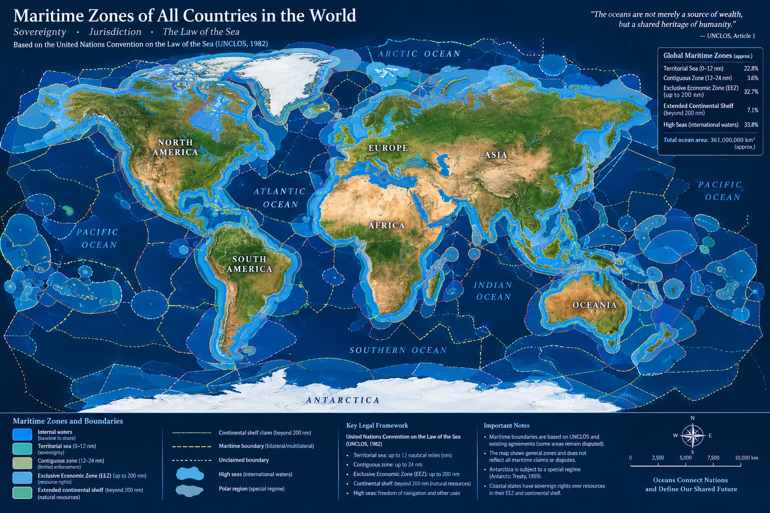
The oceans cover more than seventy percent of the Earth's surface, serving as the lifeblood of global trade, a primary source of sustenance, and a theater for geopolitical strategy. For centuries, maritime powers contested the rules of engagement on the water. Some nations claimed vast expanses of the sea to project power and monopolize fisheries, while others advocated for the principle of mare liberum, meaning the freedom of the seas for all nations. To bring order to these competing interests, the international community spent decades negotiating a comprehensive legal framework. The culmination of these efforts is the United Nations Convention on the Law of the Sea, commonly referred to as UNCLOS. Adopted in 1982 and entering into force in 1994, UNCLOS establishes a detailed constitution for the oceans, defining precise maritime zones that govern how coastal states and landlocked nations interact with marine spaces.
Understanding these maritime zones requires looking closely at how cartographers and legal experts map the oceans. Unlike land boundaries, which are marked by rivers, mountains, or fences, maritime boundaries are largely invisible lines drawn across water, calculated through complex geometric formulas and baseline measurements. These divisions balance the sovereignty of coastal states with the collective rights of the international community. Every coastal nation possesses a suite of maritime zones that extend progressively further from its shores, granting varying degrees of authority over navigation, resource extraction, and environmental protection. This article examines the framework of maritime zones, how maps represent these legal divisions, and why they remain central to modern geopolitics and international law.
How are maritime zones measured from the baseline?
The foundation of all maritime zone calculations is the baseline. Under international law, the baseline is typically the low-water line along the coast as marked on large-scale charts officially recognized by the coastal state. When a coastline is deeply indented, has islands in its immediate vicinity, or is highly unstable, states may draw straight baselines connecting appropriate points. From this baseline, all seaward maritime zones are measured. The baseline acts as the zero-mile marker for maritime jurisdiction.
Landward of the baseline lie internal waters. These include rivers, lakes, bays, and waters landward of straight baselines, as well as ports and harbors. Within internal waters, the coastal state exercises absolute sovereignty, identical to its authority over dry land. Foreign vessels generally do not have a right of innocent passage through internal waters unless specifically authorized by treaty or domestic law. Mapping internal waters is crucial for port operations, customs enforcement, and environmental liability, as any incident occurring within these boundaries falls entirely under the domestic jurisdiction of the coastal state.
What are the different maritime zones under UNCLOS?
Moving seaward from the baseline, UNCLOS establishes a series of concentric zones, each with distinct legal regimes defining the rights and duties of both the coastal state and foreign nations.
The territorial sea extends up to 12 nautical miles from the baseline. Within this zone, the coastal state exercises full sovereignty over the airspace, the water column, the seabed, and the subsoil. However, a vital exception exists: foreign ships enjoy the right of innocent passage. This means commercial vessels and warships from any country may sail through the territorial sea for the purpose of continuous and expeditious transit, provided their passage is not prejudicial to the peace, good order, or security of the coastal state. Submarines, however, must navigate on the surface and show their flag.
Beyond the territorial sea lies the contiguous zone, which extends up to 24 nautical miles from the baseline. This zone does not confer sovereignty; rather, it is a buffer area where the coastal state may exercise the control necessary to prevent or punish infringement of its customs, fiscal, immigration, or sanitary laws and regulations committed within its territory or territorial sea.
The exclusive economic zone, commonly known as the EEZ, extends up to 200 nautical miles from the baseline. Within the EEZ, the coastal state has sovereign rights for exploring, exploiting, conserving, and managing natural resources, whether living or non-living, of the waters superjacent to the seabed and of the seabed and its subsoil. This includes fishing, energy production from water and wind, and seabed mining. Despite these economic rights, other states retain freedoms of navigation and overflight, as well as the right to lay submarine cables and pipelines.
The continental shelf comprises the seabed and subsoil of the submarine areas that extend beyond the territorial sea throughout the natural prolongation of the coastal state land territory to the outer edge of the continental margin, or to a distance of 200 nautical miles where the outer edge does not extend up to that distance. Coastal states have sovereign rights over the continental shelf for exploring and exploiting its mineral and non-living resources independently of any proclamation. Where a shelf extends beyond 200 nautical miles, a complex scientific and legal submission process through the Commission on the Limits of the Continental Shelf is required to map and validate those outer boundaries.
Finally, areas beyond national jurisdiction are known as the high seas and the Area. The high seas are open to all states, whether coastal or landlocked, and are reserved for peaceful purposes. Freedom of the high seas comprises freedom of navigation, overflight, scientific research, and fishing, subject to conservation duties. The seabed and ocean floor beyond national jurisdiction, termed the Area, is designated as the common heritage of mankind, with its mineral resources managed by the International Seabed Authority.
How do maritime maps and charts represent overlapping boundaries?
Mapping maritime zones is rarely a simple matter of drawing parallel lines. Because coastlines are irregular and countries often sit geographically close to one another, maritime zones frequently overlap. When the distance between two opposing or adjacent states is less than 400 nautical miles, their respective territorial seas, EEZs, or continental shelves will intersect.
To resolve these overlaps, international law and numerous bilateral treaties rely on the principle of equidistance, or the median line. This method draws a boundary where every point is equidistant from the nearest points on the baselines of the respective states. However, courts and arbitration tribunals often adjust median lines based on equitable principles, taking into account special circumstances such as disproportionate coast lengths, coastal geomorphology, or third-party islands that might distort an equitable outcome.
Cartographers use specialized hydrographic software and GIS technology to project these lines onto navigational charts and digital maps. These maps are essential tools for maritime security, shipping logistics, and resource management. Errors in boundary mapping can lead to international disputes, illegal fishing enforcement actions, or conflicting energy exploration licenses. Governments invest heavily in precise geodetic surveys to ensure their maritime charts align with international standards set by organizations like the International Hydrographic Organization.
Conclusion
The system of maritime zones established by international law provides a vital framework for managing the world's oceans. By balancing the sovereign rights of coastal states with the collective freedoms of the international community, these legal boundaries help maintain stability and order on the water. As technology advances and nations look increasingly to the oceans for energy, food, and communication corridors, accurate maritime mapping remains more important than ever. Whether for navigating commercial cargo ships, protecting marine biodiversity, or resolving territorial disputes, understanding the divisions between internal waters, territorial seas, exclusive economic zones, and the high seas is essential for anyone engaged in maritime affairs.
Comments
No comments yet.