The Digital Trace: Electronic Navigation and the Evidentiary Challenges of Modern Maritime Law
An examination of how digital navigation data, from VDR to ECDIS, reshapes the evidentiary standards and liability frameworks in international maritime litigation.
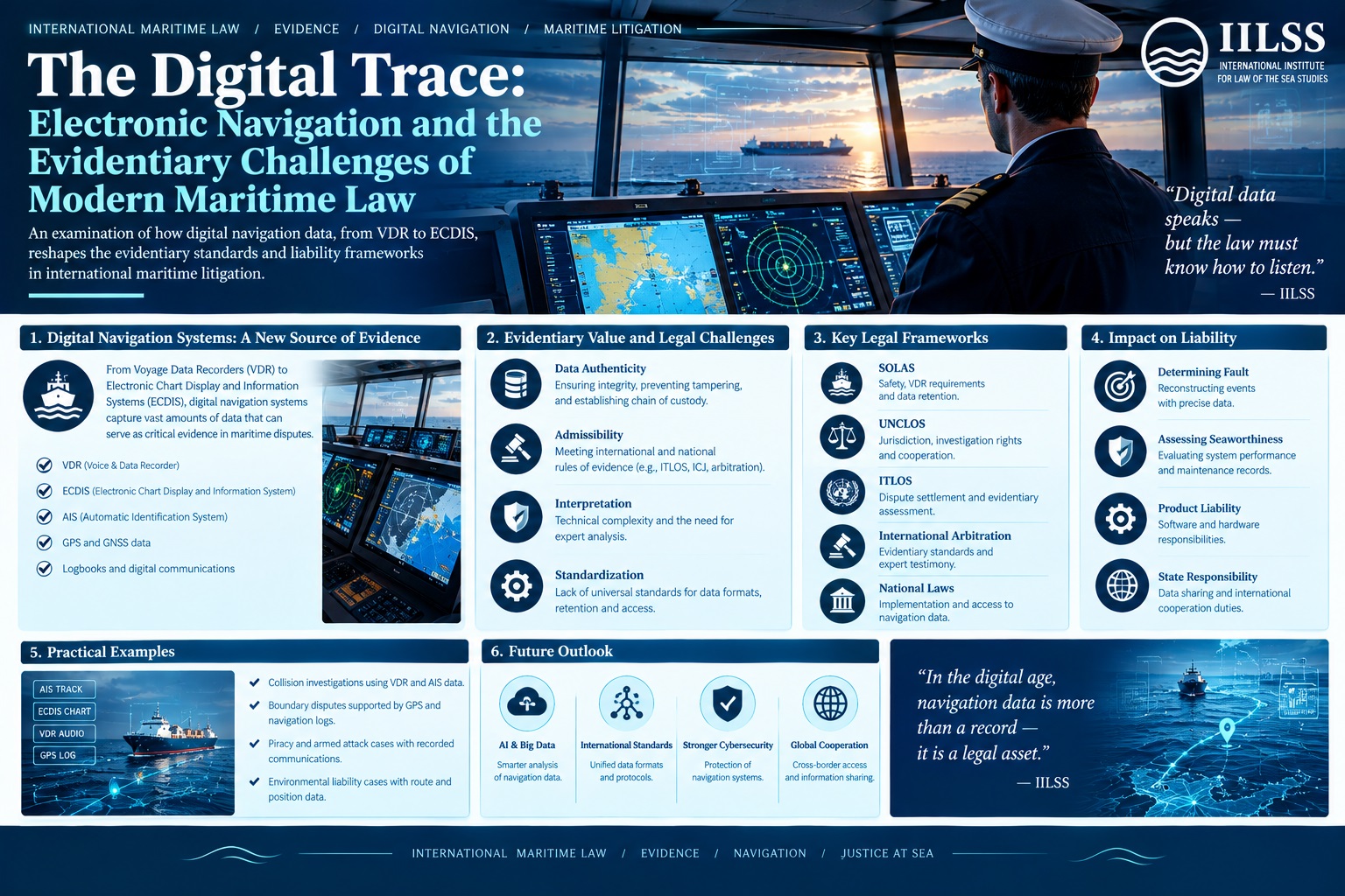
The transition from traditional, manual navigation to the digitized, sensor-driven environment of the modern bridge has fundamentally altered the epistemology of maritime law. Where once the determination of fault in a collision or grounding relied heavily upon the contemporaneous observations of eyewitnesses and the scrutiny of paper logbooks, the contemporary adjudicator is increasingly confronted with a deluge of digital artifacts. This shift from ocular-based testimony to algorithmic data presents a profound challenge to the established principles of maritime evidence, forcing courts and international tribunals to grapple with the technical nuances of Voyage Data Recorders (VDR), Electronic Chart Display and Information Systems (ECDIS), and the burgeoning threat of signal interference.
At the heart of this evolution lies a tension between the perceived infallibility of digital data and the inherent vulnerabilities of the hardware and software that generate it. As maritime litigation moves into an era characterized by high-frequency sensor data and automated decision-support systems, the legal community must redefine the standards of authenticity, integrity, and weight afforded to electronic evidence. The question is no longer merely whether a digital record exists, but whether that record represents an accurate reflection of the physical reality of the vessel's movement and the decision-making processes of its crew.
The Epistemology of Digitality: From Sight to Sensor
In the classical era of maritime jurisprudence, the concept of a 'proper lookout' under the International Regulations for Preventing Collisions at Sea (COLREGs) was understood as a human-centric obligation. It required the continuous visual and auditory assessment of the surrounding environment. However, the integration of Automatic Identification Systems (AIS) and radar-overlay technologies has introduced a layer of abstraction between the mariner and the sea. This abstraction has profound implications for the onus probandi in maritime disputes.
When a collision occurs, the tribunal must reconstruct a timeline of events. In the pre-digital age, this was a reconstructive exercise based on human memory and logbook entries. Today, it is a forensic exercise. The 'truth' is no longer found in the subjective perception of the officer on watch, but in the synchronized timestamps of various electronic systems. Yet, this digital truth is susceptible to what legal scholars might term 'algorithmic opacity'—a state where the logic behind a system's output (such as a collision alarm or an ECDIS route deviation alert) is not transparent to the user, let alone the court. This opacity complicates the assessment of negligence: was the error a failure of human judgment, or a failure of the technology to provide actionable intelligence?
How is VDR data used in maritime collisions?
The Voyage Data Recorder (VDR), often referred to as the 'black box' of a ship, serves as the primary source of objective evidence in the aftermath of a maritime casualty. Mandated by the International Maritime Organization (IMO) through SOLAS Chapter V, the VDR captures a multi-channel array of data, including bridge audio, VHF radio communications, radar images, AIS data, and various sensor inputs.
In the context of a collision, VDR data is used to establish a granular timeline of the vessel's movements and the crew's responses. Adjudicators utilize this data to answer critical questions regarding the timing of course changes, the activation of alarms, and the verbal commands issued by the Master or the Officer of the Watch (OOW). The legal weight of VDR data is generally high, often serving as the definitive record that can override conflicting oral testimony. However, the admissibility of VDR data is not without complexity.
- Integrity and Spoliation: If a VDR is found to have been tampered with, or if the data is incomplete due to a malfunction, courts may apply the doctrine of spoliation. This may lead to an adverse inference, where the tribunal assumes the missing data would have been detrimental to the party responsible for the recording.
- The Continuity of Evidence: For VDR data to be considered reliable, a clear chain of custody must be established from the moment of retrieval at the scene to its presentation in a tribunal like the International Tribunal for the Law of the Sea (ITLOS).
- Contextual Interpretation: A significant challenge lies in the interpretation of audio recordings. The lack of visual context in a VDR audio log can lead to disputed interpretations of the 'tone' or 'urgency' of commands, which are critical in determining whether the crew acted with due diligence.
"The technical precision of the VDR provides a skeleton of the event, but the legal flesh must still be provided by the interpretation of human agency within that digital framework."
What is the legal weight of ECDIS data?
The Electronic Chart Display and Information System (ECDIS) has revolutionized navigation, replacing paper charts with real-time, sensor-integrated digital maps. While ECDIS enhances situational awareness, it also introduces a new category of evidentiary risk. In maritime disputes, ECDIS logs are frequently scrutinized to determine whether a vessel deviated from its planned route or failed to account for navigational hazards.
The legal weight of ECDIS data is typically viewed as corroborative rather than absolute. While the system provides precise coordinates and depth data, the court must distinguish between the system's representation of the environment and the actual environment. Several factors influence how a tribunal evaluates ECDIS evidence:
- The 'Human-in-the-Loop' Doctrine: Courts are increasingly wary of 'automation bias,' where officers rely excessively on ECDIS alerts without verifying them through traditional means. If an ECDIS fails to trigger an alarm due to an improperly updated electronic chart, the liability may shift from the navigator to the chart provider or the flag state's regulatory oversight.
- Software and Update Integrity: The reliability of ECDIS is contingent upon the regular installation of Notices to Mariners (NtM) and electronic chart updates. A failure to maintain an up-to-date electronic database can be characterized as a breach of the duty of care, turning the ECDIS itself from a tool of safety into a piece of evidence of negligence.
- Configuration Errors: Evidence often emerges that ECDIS settings (such as safety contours or depth alarms) were improperly configured for the specific voyage. In such cases, the digital log becomes a roadmap of professional incompetence.
Can GPS spoofing be used as evidence?
As maritime operations become more reliant on the Global Navigation Satellite System (GNSS), the vulnerability to cyber-physical interference has emerged as a significant legal frontier. GPS spoofing—the deliberate transmission of false signals to deceive a receiver—can cause a vessel to believe it is in a different position, potentially leading to groundings or collisions in sensitive waters.
From a jurisprudential standpoint, the emergence of spoofing introduces the concept of 'technological force majeure.' If a vessel is led astray by a sophisticated spoofing attack, the owner may argue that the resulting casualty was beyond their control and that they exercised all reasonable due diligence. However, proving such a claim in court is notoriously difficult. To use spoofing as a valid defense, a claimant must provide high-level forensic evidence that differentiates a malicious signal from a legitimate sensor error or atmospheric interference.
The evidentiary threshold for proving spoofing requires:
- Correlation Analysis: Demonstrating a discrepancy between the GNSS position and other independent systems, such as inertial navigation systems (INS) or terrestrial-based radio navigation.
- Signal Characteristic Analysis: Providing technical data showing that the received signal possessed the hallmarks of a spoofing attempt, such as anomalous signal strength or incorrect satellite constellation geometry.
- Cyber-Forensic Reports: Expert testimony detailing the lack of standard error patterns typically associated with hardware failure.
The legal ambiguity remains: to what extent is a Master required to recognize a spoofing attempt? If the technology is so sophisticated that a trained professional cannot distinguish it from reality, the 'reasonable person' standard may shield the crew from liability. However, if the signs of interference were detectable through traditional cross-referencing, the failure to act may constitute negligence.
Who is liable for electronic navigation failure?
The determination of liability in the age of digital navigation is no longer a binary choice between the shipowner and the third-party collision vessel. The complexity of the maritime ecosystem has created a distributed liability regime. When an electronic navigation failure occurs, the inquiry must extend through several layers of the supply chain.
The following table illustrates the potential distribution of liability based on the nature of the electronic failure:
| Nature of Failure | Primary Liable Party | Legal Basis |
|---|---|---|
| Software/Algorithm Error | System Manufacturer/Developer | Product Liability / Contractual Warranty |
| Incorrect Chart Data | Hydrographic Office / Chart Provider | Professional Negligence / Contract |
| Improper System Setting | The Master / Officer of the Watch | Professional Negligence (COLREGs/SOLAS) |
| Cyber-Interference (Spoofing) | Unknown (Third Party) / Potentially No Liability | Force Majeure / Cyber-Risk Allocation |
| Hardware Malfunction | Manufacturer or Maintenance Provider | Product Liability / Maintenance Breach |
The tension between lex maritima (the customary law of the sea) and modern product liability law is evident here. While traditional maritime law focuses on the conduct of the mariner, the increasing role of software suggests that the courtroom may see more litigation directed at technology conglomerates. This shift requires maritime lawyers to possess not only legal expertise but also a deep understanding of digital forensics and software architecture.
Conclusion: Toward a Harmonized Framework of Digital Maritime Evidence
The integration of electronic navigation systems has brought unprecedented efficiency and safety to the maritime industry, yet it has simultaneously fractured the traditional methods of maritime evidence and liability. The transition from human-centric observation to sensor-driven data has created new 'blind spots' in the law—areas where the complexity of technology outpaces the ability of legal doctrines to assign responsibility.
To address these challenges, the international legal community must move toward a harmonized framework for digital maritime forensics. This includes standardized protocols for the preservation and extraction of VDR and ECDIS data, clearer guidelines on the weight of digital versus human testimony, and a robust legal definition of 'cyber-physical interference' in the context of maritime casualties. As the industry moves toward further automation and autonomous shipping, the ability of the law to parse the digital trace will be the ultimate determinant of justice on the high seas. The goal must be to ensure that while the means of navigation change, the principles of accountability and the pursuit of truth remain steadfast.
Comments
No comments yet.